
Kodaikanal – located in the state of Tamil Nadu, is one of the perfect getaway destinations for people living in Bangalore. The best way to reach Kodaikanal would be to drive down from Bangalore. Thanks to the “Golden Quadrilateral project”, road conditions are excellent and you will breeze past the beautiful landscape to reach your destination.
For more road trips from Bangalore click here
Kodaikanal is a beautiful hill station in Dindigul district of Tamil Nadu. It is also referred to the the “Princess of Hill Stations” and is one of the most sort out tourist destination in the state of Tamil Nadu. We had in the past planned many a times to visit Kodaikanal , but somehow the trips never materialized. This time around we had a long weekend to look forward and had few functions to attend in Madurai (which is pretty close to Kodaikanal), which ensured that we packed our bags 🙂
I did few checks online regarding the route and checked with my relatives and everyone suggested the following route:
Bangalore -> Hosur (40 Kms) -> Krishnagiri (90 Kms) -> Dharmapuri (140 Kms) -> Salem (201 Kms)-> Namakkal (253 Kms) -> Karur (296 Kms) -> Dindigul (373 Kms) -> Kodaikanal (463 Kms)

Drive from Bangalore to Kodaikanal
We packed all the essentials and left our home at 5 AM. It is always a good idea to leave early in order to avoid the city traffic that you might encounter near Electronic city. We took the NICE road and reached Attibele at 5:45 AM. Since it was a long weekend, there was a long queue at the Attibele toll and it took us a good 15 mins to cross it.
Immediately after crossing the Attibele Toll, you will cross the Karnataka – Tamil Nadu border and will enter into Hosur. You should be able to cross Hosur by around 6:15 AM and will find the roads open up. Continue driving towards Krishnagiri on the NH7.
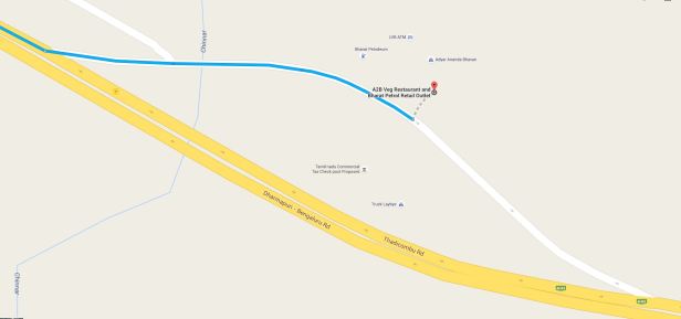
As the sun started to shine over the wide open highway, we were reminded that we had to stop to have our breakfast. We always stop by the A2B restaurant for our breakfast (I have marked this place on the map above). You will find this restaurant around 30 Kms after crossing Hosur. When this stretch was a 4-lane highway, the restaurant used to be right beside the highway, but post the 6-lane expansion, the hotel is tucked away from the highway. You will have a keep an eye on the board which directs you to the hotel.
Google Maps Co-ordinates: 12.639939, 78.064301 (Plug these co-ordinates into your GPS)
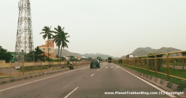
After having a sumptuous South Indian breakfast, we continued driving towards Krishnagiri. Snaps that I clicked during the drive.


As you drive further, you will reach the junction where National Highway 46 (From Chennai) would join the NH7 – to reach Dharmapuri, you should keep driving straight on NH7

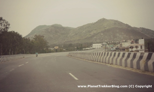
Keep driving on NH7 for another 120 Kms and you would be reaching the city of Salem by around 10 AM. Below are few snaps that I took en route to Salem from Krishnagiri.


Continue driving on NH7 and take the Salem By-pass. The city has grown significantly and to be honest, the By-pass also looks like a drive through the city of Salem :). Keep driving on the By-pass and keep a watch on the sign boards which mention “Madurai – take right”. If you miss this you will get off NH7 and would continue on NH 68 to reach Ulundurpettai. I have highlighted below the point where you need to take a right to continue on NH7.
Google Maps Co-ordinates: 11.6251081, 78.1497685 (Plug these co-ordinates into your GPS)

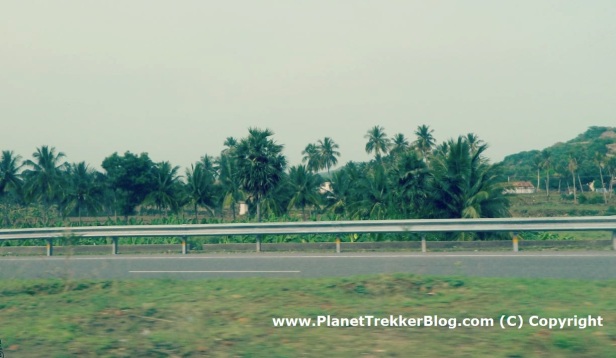
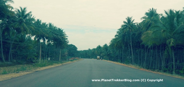
From here, the traffic becomes very thin and you can zoom past Namakal and Karur to reach Dindigul by around 12 PM. Few snaps that I took en-route from Salem to Dindigul.


Once you reach Dindigul, continue on NH-7 and take the Dindigul By-pass. Continue driving for around 4 Kms on the By-pass road and keep looking out for the left exit which would allow you to take a right turn towards Dindigul – Theni highway. It would be a good idea to slow down and look out for this turn as soon as you enter the By-pass road. The roads are so good that you might practically zoom pass this exit and end up continuing towards Madurai on NH-7.
Google Maps Co-ordinates: 10.3483816, 77.9523049 (Plug these co-ordinates into your GPS)

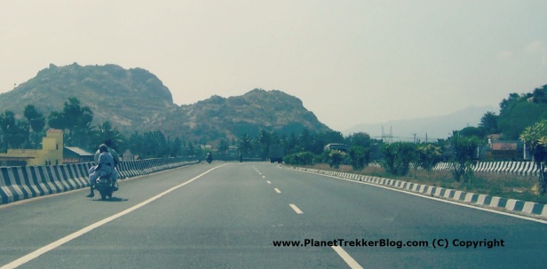
The road from here is a 2 lane state highway which is in excellent condition. When we drove down, it was freshly laid and was a pleasure to drive. The snaps below will reiterate my point 🙂


After driving for around 30 Kms on this road, you will reach the town Batlagundu. Take a right form here and continue your drive towards Kodaikanal.
Google Maps Co-ordinates: 10.1633837,77.7592367 (Plug these co-ordinates into your GPS)

After driving for around 7 Kms, keep looking for a right turn which is the road leading to Kodaikanal.
Google Maps Co-ordinates: 10.155219, 77.692374 (Plug these co-ordinates into your GPS)
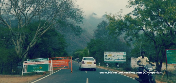
You will have to drive on the Kodai ghat road for another 50 odd Kms to reach Kodaikanal. The ghat section roads were not in great condition and it took us a good 2 hrs to reach our resort. The ghat roads are pretty narrow and steep, so be alert and drive slowly through the hair-pin and blind turns.
Read the following blog for “Driving tips on Ghat roads”. I would come in handy to know few unwritten rules related to driving through ghat sections in India.


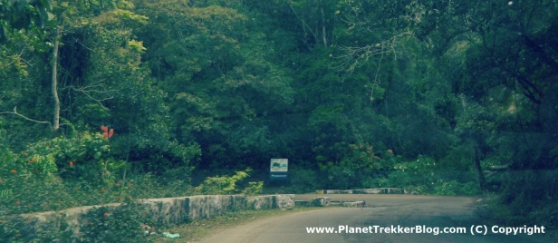

At around 2:00 PM you should be entering the city of Kodaikanal. You would be surprised by the sudden change in the weather – temperatures drop significantly and a cool breeze will keep you in high spirits. Relax yourself after a 9 hr drive in your resort before exploring “Princess of Hill Stations” – Kodaikanal !
Updates on road condition:
- March 2017 – Thanks to Kumar for providing the updates – Road condition from Bathalagundu to Kodai is Good. Few rough patches but overall drive is Good. From Perumal Malai to Kodaikanal road is very narrow as some telecom work is happening.
Like my Facebook page for regular updates on travel experiences

Thanks for the detailed explanation with snaps on Blore-Kodai road journey ! Will be travelling on 30th Jan 2017 !
LikeLiked by 1 person
Thanks Yathiender… Have a great vacation and enjoy the drive 🙂
LikeLike
Very nice blog. Clarified most of the questions that I had. Like to know whether the ghat section is covered by mountains on both side ? how steep is the ghat section. Will be traveling with my 1 year old baby so like to know much detail on ghat sections
LikeLiked by 1 person
Thanks Kumar… the ghat section is pretty steep while climbing towards Kodaikanal… while we drove the road conditions were not that great… you will find valleys on one side for almost half of the climb… the remaining distance you will find mountains on both sides… if you are travelling with a toddler would be great to have a baby seat…
LikeLike
Thanks much.
LikeLike
Just back from kodaikanal and the trip was awesome. Road condition from Bathalagundu to Kodai was good. Few rough patches but, still it was good to drive. From Perumal Malai to Kodaikanal road was very narrow as some telecom work was happening.
LikeLiked by 1 person
Thanks a lot for the update Kumar.. Will update my blog with this information.. Really happy to know that you had a great trip 🙂
LikeLike
Hi,
Very nice blog, feeling confident to drive and its my first time to Kodai . Travelling 2nd week April’17. A total of 4 of us travelling can I keep the AC on during climb ?
Thanks
LikeLiked by 1 person
And also please let me on on things to do in Kodai spread around 3N 4D .. and most importantly places to eat 😉 thanks
LikeLiked by 1 person
Thanks Robin.. Regarding the climb – the ghat section in Kodaikanal is pretty steep and with a full car and A/C on, it might be a bit of a load on the engine.. btw.. what vehicle would you be driving.. depends on that also 🙂
And as you climb towards Kodaikanal the weather tends to get cooler… you can very well switch off the A/C and enjoy the cool breeze 🙂
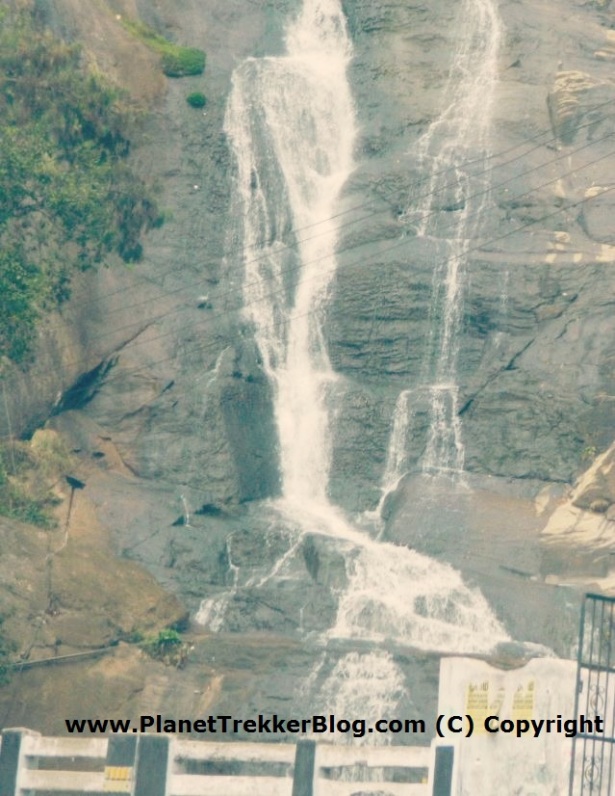
Regarding the places to visit: you can check my blog for the places that I visited during my stay.
Places to eat: During our stay, we mostly had food at the hotel that we were staying. The places that we liked were, Muncheez and Cloud street. Cafe Cariappa is a great place to have a hot coffee !!!
Hope this helps :).. have a great drive and please do let me know how was your trip
LikeLike
Hi, thanks for the info will for sure explore those places … would be driving Hyundai fluidic verna
LikeLiked by 1 person
You should have no problem then… Verna is a wonderful car for the climb
LikeLike
Thanks bro
LikeLiked by 1 person
Really liked the narration, Thanks mate!! helpful
LikeLiked by 1 person
Thanks Deepak.. glad that you found it helpful
LikeLike
Please suggest good place to take Halt between Salem and Kodai..Leaving late from Bangalore around 2pm with family.So,probably looking some some safe and good place to take night halt in between.
LikeLiked by 1 person
I would suggest you take a halt at Salem. Considering that you would be leaving Bangalore at 2pm, with the city traffic you would be reaching Salem at around 6pm… there are couple of good places like Raddisson and GRT grand Estancia which are good and located on the Outer Ring Road….
LikeLike
Hello …I and my husband were looking for blogs on best route to drive to kodai , thats when we incidentally bounced upon your blog. We plan to travel this Thursday , your details on route, timings with the pics and coordinates has helped us a lot and are now confident enough to start the drive:).Thanks!
LikeLiked by 1 person
That’s great to hear Vidya… have a great trip 🙂
LikeLike
this is great stuff – thanks. i am doing this trip next month from bangalore, after seeing this post, now confident to drive from bangalore to kodai.
Thanks a lot.
LikeLiked by 1 person
Thanks Sharath.. Have a fun filled trip… 🙂
LikeLike
very well written. very helpful.
LikeLiked by 1 person
Thanks Viswanathan
LikeLike
Q1. Did you ever visit Kodai in August. Planning to visit in the mid of august. What kind of weather can I expect? I had been to Munnar (165 kms from Kodai) in July and it was Misty the entire time. Also – how are the markets in Kodai? Planning to get a few fresh and organic grown spices.
Q2. Taking my brand new Grand i10 (just took the delivery yesterday). Will that be a problem? Brand new car up on hilly roads climbing steep slopes? I have done Ooty(via Masinagudi) twice on a 10K driven Eon (800cc). Had no problem what so ever on that. Worried for how the new engines will pull up on the slopes.
LikeLiked by 1 person
Hi Ritwik,
Please find below response to your questions
A1. Kodaikanal is blessed with good weather throughout the year. The temperatures rarely go into the 30+ degree centigrade zone. Having said that, in August you can expect rain during the afternoon and evenings. Do carry winter wear as it gets pretty cold during the evenings and night. You will find many shops in the local market selling spices. We also got a bunch of stuff when we were driving back to Bangalore
A2. It should not be a problem at all. Now a days car engines are way more reliable and sturdy as compared to the old vehicles. You should have no problem negotiating the 40Km uphill climb. If you want to take it easy, switch off the AC (you would not be needing one for sure 🙂 ) and also take a quick break in one of the hairpins to give your new machine a breather. Also.. how many people would be in the car makes a huge difference.. you have not mentioned that in your question
LikeLike
4 people with 2 suitcases. I just got my first service done. Car’s a lot smoother now. Hope the engine pulls through well.
And did you get a chance to drive to munnar from kodai? i’ve heard the roads are in the poorest of conditions.
LikeLike
It should not be a problem… just ensure that you are driving in a lower gear…
when I drove last time around road from Kodai to Munnar was not in great condition and was also very narrow.. you need to be careful while negotiating the curves at Munnar..
LikeLike
Hi, We are 3 adults and a pet and we have planned for a trip on the long weekend in the last week of August , and we plant to start from Blr around 4:30 A.M.
We have a Tata Zest car , 2 years done .
1) Considering a breakfast and one or two small breaks, when do you think we can make it to Kodai ?
2) How long does it take to navigate the ghat section ?
3) Any favorite north Indian/Chinese/Continental place to have food at Kodai ?
LikeLiked by 1 person
Hi Saurav.. My responses below:
1) Considering a breakfast and one or two small breaks, when do you think we can make it to Kodai ?
It usually takes around 8 hours to reach Kodaikanal from Bangalore.. Add a 30 minutes breakfast break and another 15-30 mins for the stopovers.. You should be taking around 9 hours i.e ETA would be 1:30 PM.
Start early to avoid the long weekend rush at the Attibele and Krishnagiri tolls… Last time around I took a good 30 minutes in each of these tolls as there was mile long queue of vehicles.
2) How long does it take to navigate the ghat section ?
Ghat section is around 50 kilometers and should take you around 1 hour to 1.25 hours.. depending upon the traffic. considering that you are going to do the trip during long weekend.. expect many vehicles on the ghat section
3) Any favorite north Indian/Chinese/Continental place to have food at Kodai ?
Veg or Non veg options?
LikeLike
For the food i.e. non veg option
LikeLike
You can try out Nias Treats – which is a small cafe serving some great food.. I also tried out some local small hotels serving amazing Chicken Kottu Parotha… If possible try the “Veechu Parotha” which is very thin (similar to roomali roti)
LikeLike
Great post, and discussions here! Thanks for the insights. I am planning to drive to Kodaikanal from Bangalore this Thursday, Aug 24. My specific questions are:
1) If I need a break for a quiet place at around 9 am for some probable work-calls, where do you think I should stop (is there any, without lots of noise either in restaurant or of the highway traffic)?
2) If it rains in the afternoon (as the forecast says for this week on most days), is it safe to drive in the ghat section?
LikeLiked by 1 person
Thanks Abhi.
Please find my responses below:
a. can you let me know what time do you plan to start? There are many places where you can park the car and take a call. Loads of places around A2B, SaiSangeet, GRT Grande hotel in Salem etc. Depending upon your start time, I can suggest the place.
b. Which car would you be driving? Irrespective of this info, I think you can drive safely through the ghats in rains.. Just ensure that you have your wipers, Brakes and tires checked/replaced before heading out for the drive. If you have fog lights in your car, switch them on and use your horn in all the turns.. If the downpour is too heavy, slow down and watch out for those invisible potholes..
Hope this information helps.. and have a great trip :).. Would be glad to answer any other question that you have..
LikeLike
Great blog! Thanks for all the tips and suggestions.. I am planning to drive from Bangalore to Kodaikanal later this week (on Thursday, 24 Aug) just before the long weekend starts.
This is a specific question, if someone can address: If I want to take a logical break (say breakfast, or later) for about an hour starting 9am on the way (for some calls without network interruptions and low background noise) to Kodaikanal at a quiet place/ restaurant on the way, where would that be?
LikeLiked by 1 person
There is also a CCD near dharmapuri (falls on the other side of the road whole driving from Bangalore to kodaikannal) which is perfect for your break
LikeLike
That a Great and detailed Blog ! Just wanted to check if I can carry my whiskey bottle along. Is there any check posts along the way where the checking would be done ?
LikeLiked by 1 person
Thanks Sunil… Sorry do not have much info on this… In general not a great idea
LikeLike
Hey Sunil,
There are checkposts just before you hit the kodai ghats (as they call it). I wasn’t checked at these posts personally so cannot comment.However, liquor is readily available in kodai. you shouldn’t bother carrying during your drive.
LikeLiked by 1 person
Amazing,Probably this is the best post i have ever read . Very interesting and informative. Thank you for sharing your experience with us.
LikeLiked by 1 person
Thanks a lot for your kind words
LikeLike
Hi Great blog… I am planning to go to Kodaikanal by end of May by Nano car.. Pls suggest if Nano will go to Kodai kanal or not, I have driven Nano ooty and some other long trip,…. Just need to understand for Ghat section for Kodai kanal
LikeLiked by 1 person
Thanks Shailendra for the kind words. If you have taken your nano through the 36 hairpins of port, kodaikanal climb would be a cakewalk. But if you had taken the Gudalur route then you might want to consider the load that the car would be carrying
LikeLike
Hi My trip plan is as below, will the duration be enough to explore Kodai ?
I am planning to leave on 31st August 2018 and return on 2nd Sept 2018.
LikeLike
It might be a bit of a stretch. You will have only 2 days .
LikeLike
is it ok to carry alcohol to kodai, will there be checking? what are my options
LikeLike
I usually refrain from carrying alcohol in the car while driving. Saves loads of problems in case your vehicle happens to be checked thoroughly. 🙂
LikeLike